Government Projects Using GPS that Enhance U.S. Security, Economy, and Safety
Borbas Surveying and Mapping maintains a System for Award Management (SAM) registration with the federal government (formerly Central Contractor Registration, CCR) which enables us to team on important projects that enhance our nation’s security, economic prosperity, health, and welfare. By implementing GPS in our work early on, we’ve been an integral part of several important government contracts.
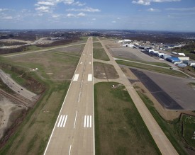
Helping Ensure Safer Landings
Global Satellite Positioning technology, GPS, and Global Navigation Satellite System (GNSS) are becoming staples of the Federal Aviation Administration (FAA).
We were hired by an FAA consultant to complete the important task of verifying the mapping and positioning of runways for a major regional airport in northern New Jersey.
Our findings revealed that the original surveyors’ maps had the runways misaligned with the global satellite system used in flight navigation. Had this incorrect data been implemented into the federal system, it would have put aircraft off track when attempting to land, and could have had tragic consequences.
As a result of this crucial discovery, Borbas has become a respected and integral team member when it comes to providing mapping control for satellite-based aircraft navigation.